Marine Geophysical Route Surveys: Uncompromising Hazard Defense for Linear Assets
Marine routing through complex island waterways and active volcanic arcs exposes offshore developments to unforgiving geological hazards: active seismic faults, shallow biogenic gas wipeouts, submarine slide scarps, unexploded ordnance (UXO), and unpredictable coral pinnacles. Uncalibrated contractor survey data often conceals these critical geohazards, triggering multimillion-dollar vessel standstills and cable route abandonment during installation.
GEOPROVE operates as your independent client-side fiduciary: "The Brain, Not the Barge." We specify precision geophysical survey programs, provide veteran 24/7 offshore Client Representatives (QC) aboard survey vessels, and perform rigorous third-party data processing. We correlate sub-bottom acoustic horizons with magnetics and side-scan mosaics to map every subsurface hazard before you finalize EPC installation contracts.
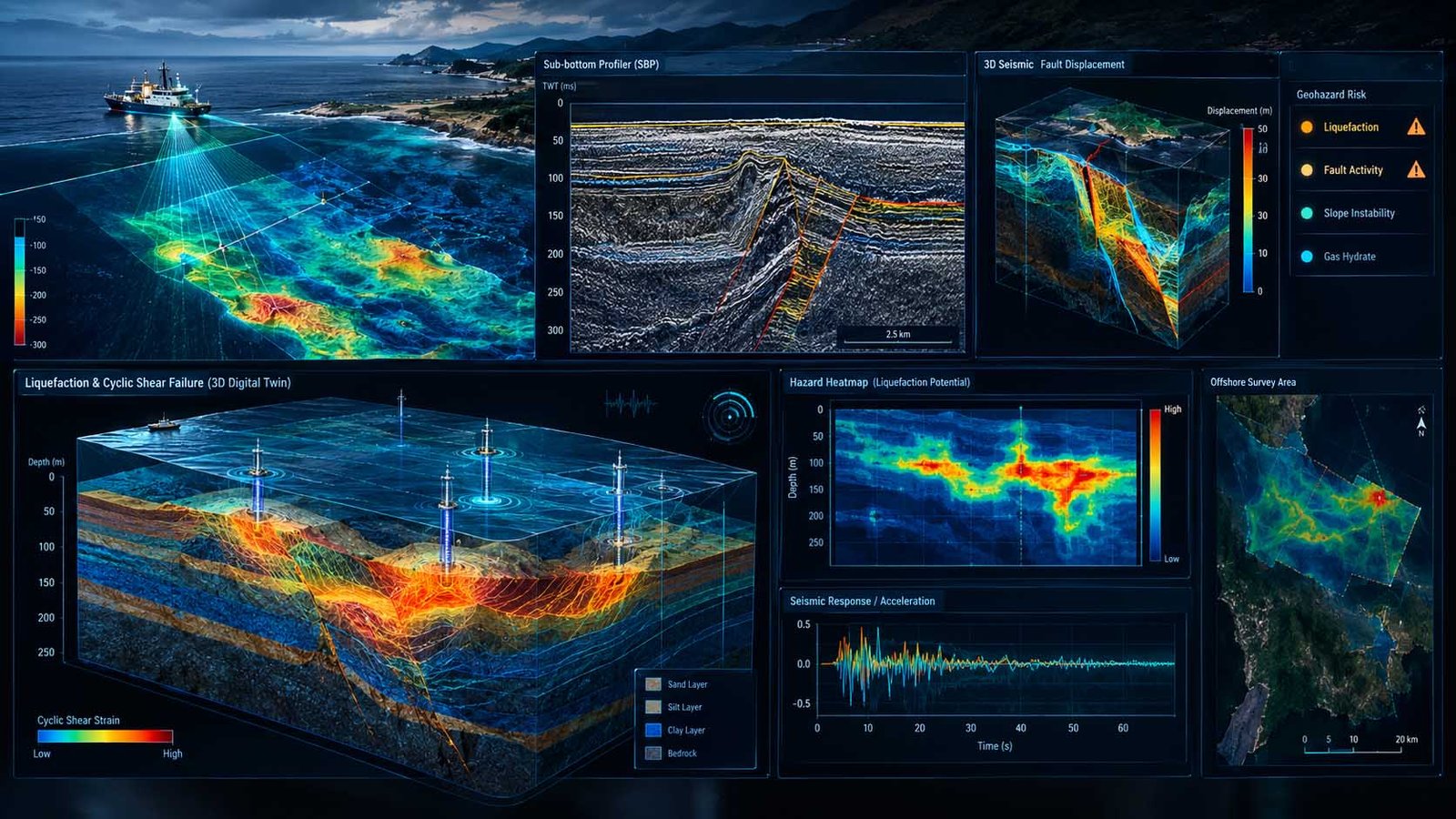
High-Resolution Sub-Bottom Profiling (SBP)
Parametric chirp and boomer acoustic seismic reflection profiling to delineate sub-seabed geological stratigraphy, shallow gas charging, and buried paleochannels down to 40m.
Dual-Frequency Side-Scan Sonar (SSS)
100/400 kHz acoustic seafloor imagery identifying boulder fields, telecommunication cable crossings, coral reef boundaries, and shipwrecks with centimeter-grade resolution.
Marine Magnetometer & Gradiometry UXO Scans
Total magnetic field and transverse gradient logging to isolate ferrous anomalies, unexploded ordnance (UXO), buried pipeline infrastructure, and abandoned wellheads.
Offshore Client Representative (QA/QC)
Senior geophysicists deployed offshore representing the developer to enforce navigation accuracy, verify daily acoustic calibration, and eliminate contractor data padding.
Why Independent Geophysical Survey Oversight is Crucial
How client-side geophysical specification protects developers against contractor scope cutting and unexpected offshore variation claims.
Preempting Subsurface Gas Blowouts & Wipeouts
Shallow biogenic and thermogenic gas pockets eliminate shear strength and create acoustic wipeout zones. We map acoustic turbidity to re-route cables and foundations around unstable zones.
Eliminating Unplanned Cable Crossings & UXO Risk
Magnetic gradiometry and high-frequency sonar resolve unchartered abandoned subsea cables and military ordnance, preventing hazardous trenching tool impact and statutory liabilities.
Watertight Geohazard Baseline for EPC Tenders
Independent acoustic interpretation converts raw sonar lines into an auditable 3D GIS Geohazard Register that disarms contractor Differing Site Condition (DSC) claims before procurement.
Proven Value of Independent Marine Geophysics
Our independent route scoping eliminates redundant vessel survey line-km and shields assets from catastrophic seabed hazards.
Our 4-Stage Marine Geophysical Survey Program
Survey Scope Design & Sensor Specification
Tailoring acoustic frequencies, line spacing, runline offsets, and crosslines based on target resolution, water depth, and local seabed geology.
Offshore QC & Client Representation
24/7 onboard monitoring of signal-to-noise ratios, USBL positioning calibration, sound velocity profiles (SVP), and daily line acceptance audits.
Integrated Seismic & Acoustic Processing
Bandpass filtering, swell compensation, gain curve balancing, and multi-sensor georeferenced mosaic synthesis in Kingdom / SonarWiz.
Quantitative Geohazard Alignment Sheets
Generating integrated route corridor charts, seabed feature databases, and GIS hazard polygons ready for engineering FEED insertion.
Survey Contractor Package vs. GEOPROVE Fiduciary Oversight
The difference between turnkey contractor survey bundles and independent client advocacy.
| Assessment Parameter | Contractor Proposal / Standard Method | GEOPROVE Fiduciary Advisory |
|---|---|---|
| Survey Scope Scoping | Frequently over-specifies redundant line-km or under-specifies acoustic penetration in difficult calcarenite ground. | Bespoke Optimization matching exact engineering design depths, eliminating unnecessary vessel charter days. |
| Offshore Data Quality Control | Self-regulated offshore contractor QC often accepts noisy acoustic records during adverse weather to avoid weather standby penalties. | Independent Client Rep enforcing strict contractual reject criteria before survey vessels leave the field. |
| Acoustic Horizon Correlation | Automated horizon picking without ground-truth geotechnical core calibration, leading to incorrect soil type classifications. | Core-Calibrated Horizon Profiling tying SBP reflectors directly to in-situ CPTu tip resistance layers. |
| Pushidrosal Hydrographic Validation | Survey raw files often require rework due to non-compliance with Indonesian Navy datum standards. | Seamless Pushidrosal Compliance formatted to Indonesian hydrographic bathymetric chart norms. |
Geophysical Acoustic & Electromagnetic Sensor Arsenal

Chirp & Parametric Sub-Bottom Profiler
Emits frequency modulated acoustic pulses (0.5–12 kHz) penetrating seabed sediments to resolve stratigraphic layering, buried bedrock pinnacles, and fault displacements.

High-Frequency Digital Side-Scan Sonar
Sweeps the seafloor with lateral fan-shaped acoustic beams creating acoustic backscatter reflectivity mosaics to map boulder fields, pipelines, rock outcrops, and trawl scars.

Overhauser & Cesium Vapor Magnetometers
Measures total magnetic field intensity anomalies to locate buried ferromagnetic objects, active pipeline crossings, submarine cable junctions, and sunken ship relics.

Intermediate-Depth Multi-Channel Seismic (MCS)
Electrochemical discharge acoustic source providing high-energy acoustic pulses for deeper foundation design, offshore wind monopile penetration, and regional fault zone mapping.
Frequently Asked Questions on This Practice
We enforce rigorous adherence to IHO S-44 Order 1a/Special Order for acoustic positioning and hydrography, IMCA S003 for offshore geophysical survey operations, and DNVGL-RP-0360 for subsea corridor routing. All line spacings and overlap margins are verified by our Client Representatives.
Offshore vessel charter day-rates range between $25,000 and $65,000. Without client representation, contractors may speed through lines, ignore poor signal-to-noise ratios during high swells, or terminate runs prematurely, leaving critical gaps that invalidate subsequent engineering calculations.
SBP acoustic profiles detect buried caprock, calcarenite ridges, and boulder beds lying 1–3m below the mudline that are invisible to surface bathymetry. Identifying these layers early allows developers to specify mechanical chain trenchers instead of failing with jetting sleds.
Historical naval engagements and World War II minefields present severe risks in Southeast Asian straits. GEOPROVE designs dense transverse magnetic gradiometry grids, establishes target hazard registers, and assists in coordinating naval explosive ordnance disposal (EOD) protocols.
Yes. All bathymetric and geophysical alignments are delivered fully projected to WGS84 / UTM and standardized to Pushidrosal S-57 / S-100 electronic navigational chart requirements to guarantee immediate statutory acceptance.
Initiate a Marine Geophysical Survey Scoping Session
Provide your corridor coordinates and water depths for an independent survey specification and QC plan. All inquiries protected under strict corporate NDA.